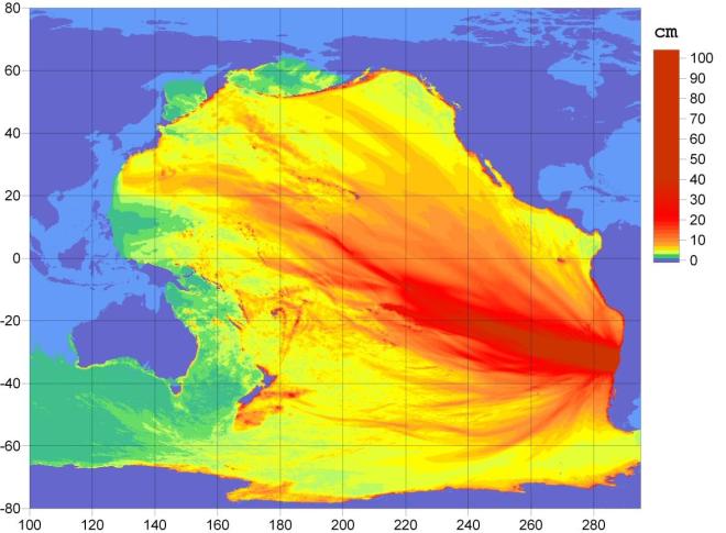
- Ocean Energy Distribution from Chilean Earthquake via NOAA
8.2-foot tsunami wave expected to strike Hilo, Hawaii 11:05 a.m. local time (4:05 p.m. ET) according to the Pacific Tsunami Warning Center. Tsunami advisory extended to Oregon, Washington, parts of Alaska, coastal British Colombia by West Coast Alaska Tsunami Warning Center
Here is the map of the Chilean earthquake and aftershocks from the USGS.
Good research really. The tsunami is quite dangerous for countries in South America and Soth Asia
hey, recent storm at france … what about that? my dad’s ship is following the route from argentina to algeria. has this storm effected his way? m worried..let me know every bit to assure me that he is safe out there
hi my dad he is sailing towards algeria (atlantic ocean)he left argentina on 22 feb.Is there any chances of finding sea rough in that route because of tsunami(if any)
No.
hi. my husband is on ship horizon hunter 1st engineer. i believe they left oakland, ca port late wed. 25th. he’d normally be in hawaii by now. do they just stay out in the ocean when such things happen (tsunami)?
Although I have never actually experienced a tsunami, my understanding is that the safest place for a ship to be is at sea, offshore. In fact, vessels sometimes might not even realize that a tsunami has passed. Trouble occurs when depths get shallower and the big wave shortens up and begins to break. Here’s a very brief description from the National Maritime Museum in Greenwich, England. A ship in port is more vulnerable but with technology that allows for more advance warning, crew and passengers will most likely be evacuated.
Hope this information is helpful.